Three Scenes and Speculations from a Future City
Rami El Samahy and Adam Himes
If all design can be seen as a way to predict – and shape – the future, no field should be more forward-looking than urban design and planning. However, planners tend to be fairly cautious, relying on historical precedents rather than future trends in shaping cities. There are perfectly rational reasons for this tendency: the past is a more knowable territory than the future. And yet, do we limit our vision if we fail to untether ourselves from the past, and seek design opportunities for the future?
Our research team – architects and designers curious about alternative approaches to designing the urban future, especially as it relates to the Middle East – began by creating a digital compendium of all the predictions we could find (past and present) that were related to the future of urban environments. We tagged and sorted these in various ways to see what we might uncover. Among our most interesting (and obvious) discoveries was that projections into the future are more telling about the present in which they are created. For example, many of the anxieties of the 1980s revolved around a potential nuclear Armageddon; today, it’s ecological disaster that terrifies us.
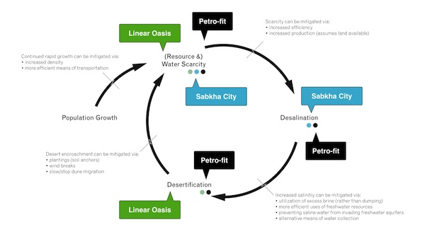
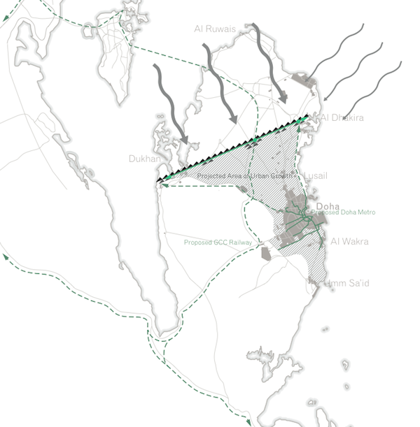
We then focused our lens on urbanisation in the rapidly developing world, specifically exploring the design possibilities in a future desert conurbation, one perhaps very similar to Doha, Qatar and its environs. Doha intrigues us for a number of reasons. While it is unique in many ways (high standards and ambitions, the world’s largest GDP and carbon footprint per capita, and a overwhelmingly expatriate population), the rapid population growth and frenetic urban/suburban development here can be seen as harbingers of things to come elsewhere. The number of people living in Qatar has trebled in the past seventeen years, and four-fifths of them live in the greater Doha area, which has quadrupled in size during that same time, growing not only up, but out as well. [i] Inevitably, this growth has put a great strain on the fragile desert and marine ecosystems upon which the city sits. [ii] The relationship between some of Doha's most challenging issues is illustrated below.
4dDoha Research & Design
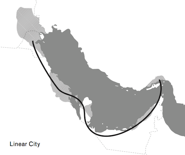
The city’s rapidly increasing population exacerbates a feedback loop of increasing water scarcity, desalination and desertification. Each of the three projects below proposes a potential integrated solution to some or all of these issues for a future Doha. We examined three distinct scenarios in greater detail, and offered three potential future design proposals: the Linear Oasis, a hybrid vegetative and mechanised wall designed to address issues of desertification and urban sprawl; Sabkha City, a possible response to rising sea levels and issues of desalination; and Petro-fit, a regionally-scaled investigation of possible uses for the infrastructures of oil and gas following the industry’s demise.
Scenario One: Desertification
Desertification threatens over one-third of the Earth’s population and affects over 40% of its land area. More than twelve million hectares of arable land are lost every year to desert encroachment. Despite this consistent loss of land, the UN projects that to support a predicted population of nine billion people in 2050, a 70% increase in food production would be required. [i]
As a windswept desert peninsula, Qatar’s geography and climate have forced it to import 90% of its food. [ii] Its meteoric population growth has all but exhausted what scarce groundwater reserves it had. Overexploitation of underground reservoirs has caused seawater to creep in, contaminating the water table and hastening the demise of agricultural productivity. Qatar’s increased population, sprawling urban settlements and consumption habits only add to the strain on already limited resources. As the vegetation that anchored the soil in place erodes, a rapidly expanding populace will be exposed to stronger and more frequent sandstorms. The increased number of people and the inefficiency of their settlement may well overtax Qatar’s dwindling water and food resources.
Speculation One: Linear Oasis
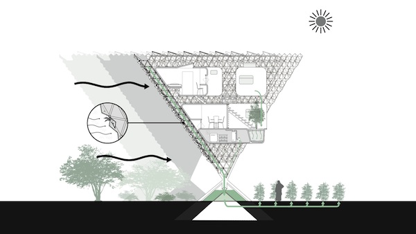
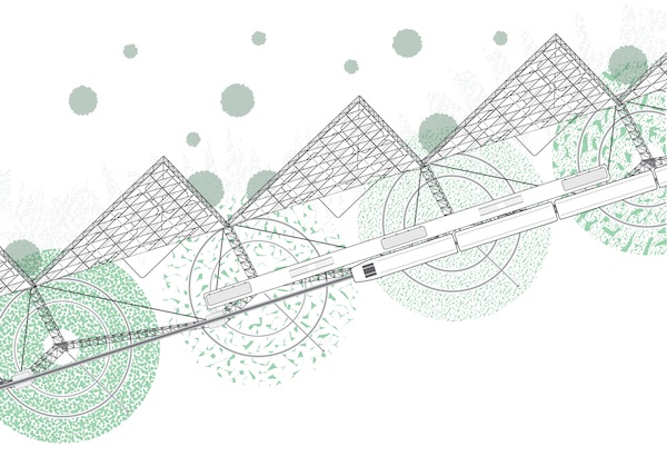
The Linear Oasis is a hybrid botanical-mechanical infrastructure that provides integrated solutions to the problems of desertification, resource scarcity and urban sprawl at a regional scale. It serves as a barrier to sandstorms, a self-sustaining source of water and food, and a limit to urban growth. After the construction of its most basic infrastructure, the Linear Oasis can passively collect water from the atmosphere, subsequently supporting local agriculture, live-work settlement and transit infrastructure.
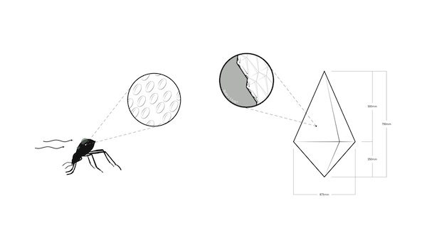
The Linear Oasis is reminiscent of fractal geometry, using similar forms at multiple scales for a variety of effects. Operating at its largest scale, it is a wall spanning the breadth of Qatar, built perpendicular to the prevailing winds to shield the majority of Qatar’s population from sandstorms. The orientation of the components is echoed in each of the building units, which take the form of inverted triangular pyramids. When aggregated, these comprise a nationwide green wall that cleans the desert air as it passes.
Equally important is the fact that, due to Qatar’s peninsular condition, breezes blow inland from the Gulf, carrying moisture with them. By intelligently shaping and nano-texturing the smallest components of the system, this moisture can be collected from moving air. This type of surface occurs naturally in the shell of the Namib Desert beetle, which is composed of alternating hydrophobic and hydrophilic areas that pull moisture from the air at the nanoscopic level. [iii]
4dDoha Research & Design
Most water collected from wall components flows down the face of each pyramid towards a central holding tank integrated into the base of each unit. The water tank feeds into a drip-irrigation system that supports small-scale agriculture along the southern face of the wall. These plots are tended by live-in farmers who reside in modular housing units installed in the space-frame structure on the southern face of the pyramidal units.
 4dDoha Research & Design
Residents of the Linear Oasis are linked to each other, and their produce to urban centres, via a light-rail transit line that runs along the top of the wall from the east to the west. Transit along the Linear Oasis has the potential to tie into the proposed national metro and rail systems. The integration of these transit lines suggests a third line that would in turn delineate an ideal area for future urban growth that is well-serviced by transit, protected from sandstorms and securely supplied with food and water.
4dDoha Research & Design
Scenario Two: Rising Water
Continuing global climate change is expected to result in both increased temperature and sea level, the effects of which will be magnified in the world’s most heavily populated urban centres. Almost half of the global population lives within 100 kilometers (62 miles) of a coast, [i] including twenty-three cities with populations over 5 million. [ii] Rising seawater not only threatens cities with inundation, but can also contaminate underground freshwater aquifers. Should sea level rise by even 1 m, 41,500 km 2 of coastal land in GCC countries will be adversely affected.[iii] Forecasts of a 1 mincrease are generally considered baseline; some experts predict upwards of 2 m by the century’s end. [iv]
At the same time, desalination is a reality of the region, with just under half of the world’s plants located on the perimeter of the Gulf. [v] Separating the salt from the water provides a valuable source of potable water that has allowed these desert cities to thrive, but the process has two major downsides: first, it is energy intensive, and second, the brine that is dumped back into the Gulf threatens the fragile marine environment.
Speculation Two: Sabkha City
A sabkha (?sæbk?) is an area of coastal flats subject to periodic flooding and evaporation, which result in the accumulation of aeolian clays, evaporites and salts, typically found in North Africa and Arabia. [vi]
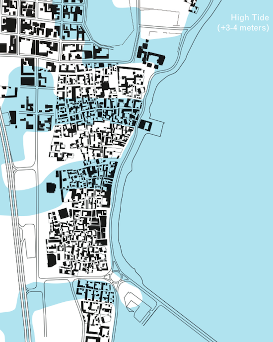
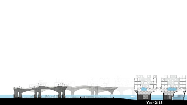
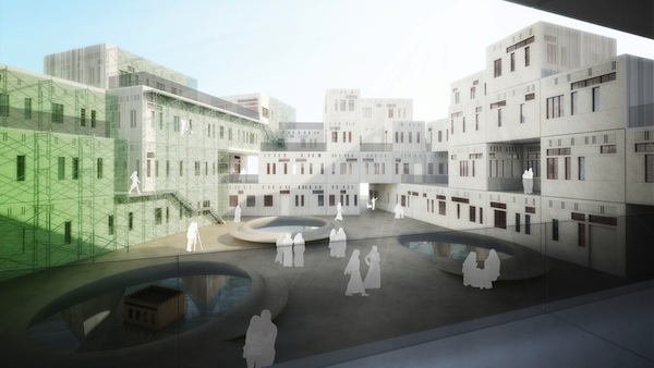
Sabkha City is a phased urban strategy to adapt an existing coastal settlement for use after rising sea levels have made its continued habitation untenable. Rather than attempt to stem or to mitigate the effects of littoral encroachment, it accepts the impending inundation of the area and subverts the destructive potential of seawater into the driving force enabling future occupation. As sea levels rise, the Sabkha City grows larger; tidal surges generate freshwater and building material. By century’s end, the city becomes an elevated oasis of land surrounded by water.
 4dDoha Research & Design
Due to its low-lying coastal location on the increasingly saline Gulf, [i] as well as the growing pressure placed on its limited freshwater resources, al Wakra, Qatar, will serve as a case study for the application of the Sabkha City strategy. Focusing on al Wakra’s historical village – an area of cultural significance to the country – demonstrates how this strategy could address a desire to preserve portions of an otherwise inundated original settlement.
4dDoha Research & Design
Initially, Sabkha City is a skeletal framework of scaffolding, mesh, pulleys and raised walkways linking the most important sites within the historical village. Villas in the flood plain are selectively sacrificed, becoming solar stills or storage tanks within a larger, tidally operated passive-solar desalination system. In addition to providing a constant supply of drinking water, the system disperses the excess brine over the mesh and scaffold framework, where the saline mist evaporates into a crust of salt, thickening over time into an elevated plain. The city’s skeleton deteriorates beneath its saline coating, leaving behind a fused carapace of salt columns and an irregular network of vaults. Over time, new living spaces can be built on or carved from the synthetic landscape to replace those that will inevitably flood below.
4dDoha Research & Design
Scenario Three: The end of Oil
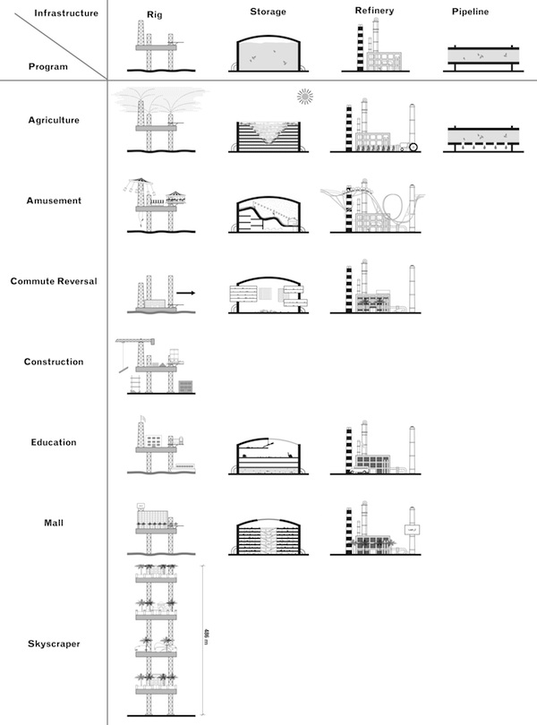
Sometime around the year 2100, all oil and natural gas in the Middle East will be depleted. [i] Miles of pipeline, scores of massive storage tanks, refineries the size of cities, and the 120 offshore oil and natural gas rigs that ply the Gulf today will all be abandoned. The sheer scale of this ‘leftover’infrastructure is difficult to comprehend. The offshore platforms alone span almost 450,000 m 2 and could stretch 7.6 km if placed end to end. Each liquid natural gas (LNG) storage tank at Ras Laffan Industrial City, Qatar, has a capacity of 140,000 m 3, measuring 78 m in diameter and almost 40 m high. [ii] Ras Laffan itself covers 295 km 2;the municipality of Doha covers 132 km2. The question is simple: what can be done with this infrastructure?
Speculation Three: Petro-Fit
The size and quantity of these elements create opportunities at a variety of scales through a programme of creative adaptive reuse of this soon-to-be-defunct infrastructure. The offshore rigs, which are designed for relocation, offer particularly exciting potential for recombination.
At the regional level, the rigs could be strung together to fashion piers for a new mega-causeway that capitalises on existing and planned links in the Gulf. From Basra to Musandam, much of the Arab edge of the body of water is currently populated and urbanised; strategic use of this infrastructure would cement the linear megalopolis that is already underway. [iii] A more ambitious iteration would link both the northern and southern sides of the Gulf, allowing for free movement of people and goods between the waterfront cities in the Arab peninsula and Iran.
4dDoha Research & Design
At the urban level, Qatar might consider constructing a new Doha Bay, or completing the current crescent shape to form a circular means for pedestrian and vehicular perambulation. The rigs offer a number of potential retrofits, dependent on the national priorities: agriculture, amusement, education, retail super malls, live-work office parks.
4dDoha Research & Design
Of particular interest is the residential rig-tower, which would be one of the tallest buildings in the region, if not the world. Unlike the typical tower, it would allow for a series of interventions at each level, including unrealised or relocated projects for the city. In these ways, the infrastructure might be repurposed to allow for a variety of possibilities, depending on the city’s needs and priorities.
 4dDoha Research & Design
Conclusion
Development in Doha over the past decade has outpaced all expectations, and laudable investments in culture, sports and health are materialising at a surprising rate. For cities like Doha and it citizens, things have never looked better. So why offer such seemingly bleak visions of the future for a region that is currently enjoying its moment in the sun? While seemingly far-fetched scenarios, each of the options represents distinct possibilities for solutions should conditions continue along current trajectories. These speculations are intended to provoke thought, and to question the current modus operandi. In the end, what is needed is enlightened clients (and a general public), who approach future growth with a long view rather than the typical developer-driven cycle that demands a return on investment within eighteen to thirty-six months.
One glaring omission in our speculations on Doha involves the role that its future inhabitants might play in its development. In fact, this remains among the most pressing questions for the city’s future. Today, the situation is such that nationals comprise about 6% of the overall workforce. [1] Will it continue to be a city in which only a small minority are truly inhabitants, the rest transitory blue- and white-collar labourers? Will it become a city with a Qatari majority, or will it become a city of global citizens, where all who work for it are made to feel that they belong?
Text: Rami el Samahy & Adam HImes
Research & Design: Rami el Samahy, Adam Himes, Phillip Denny, Keith Lagreze, & Kennan Rankin
1. Qatar National Census 2010. See also author’s research at www.4dDoha.com.
2. Renee Richer, Conservation in Qatar: Impacts of Increasing Industrialization , Georgetown University Center for International and Regional Studies, 2008. http://www12.georgetown.edu/sfs/qatar/cirs/ReneeRicherCIRSOccasionalPaper20082009.pdf (accessed ???).
3. Environment News Service, ‘UN Leaders Focus on Preventing the Spread of Deserts | Environment News Service’, Environment News Service, http://ens-newswire.com/2011/09/21/un-leaders-focus-on-preventing-the-spread-of-deserts/ (accessed 31 January 2012).
4. Arwa Aburawa, ‘Qatar to Invest in 1,4000 New Farms’, Green Prophet, http://www.greenprophet.com/2011/08/qatar-14000-new-local-farms/ (accessed 31 Janurary 2012).
5. Scientists at the Massachusetts Institute of Technology have developed materials and appliqués that mimic the properties of the beetle’s shell, though at the time of writing, they have not yet entered the public market.
6. Estimates vary widely on this statistic, ranging from as low as 23% (Greenpeace) to as high as 60% (Global Environment Facility). Almost all sources define the ‘coast’as the near coastal zone, an area within 100 m (328 feet) in elevation and 100 km (62 miles) of the coast. Whether the coast is defined solely as an area adjacent to a sea or the ocean or if it includes river coastlines is unclear and may account for the statistical variability. While a consensus is difficult to determine, between 40–50% seems the most plausible.
7. ‘Sea Level Rise | Greenpeace International’, Greenpeace | Greenpeace. http://www.greenpeace.org/international/en/campaigns/climate-change/impacts/sea_level_rise/?accept=183de9769c809dbff492c7cf057afbcf (accessed 30 January 2013). Twelve of these cities have populations over 10 million.
8. Satish Kanady, ‘Rising Sea Level Poses Risk to Qatar, Neighbors’, The Peninsula Qatar, http://www.thepeninsulaqatar.com/Display_news.asp?section=Local_News&month=November2009&file=Local_News200911281256.xml (accessed 13 June 2012).
9. Thomas Rogers, ‘The Flooded Earth: Which of Our Cities Can Be Saved?’, Salon, http://www.salon.com/2010/07/06/the_flooded_earth_interview/singleton/ (accessed 13 June 2012).
10. Emmanuelle Landais,‘Waste dump threatens Arabian Gulf’, Gulf Newshttp://gulfnews.com/news/gulf/uae/environment/waste-dump-threatens-arabian-gulf-1.72058 (accessed 11 January 2014).
11. Oxford Dictionaries, s.v. ‘sabkha’.
12. As of 2005, desalination plants were responsible for discharging in excess of 10,000,000 m 3 of brine waste into the Gulf per day. This has probably increased as more desalination plants have come online in the intervening years. See A. Hashim and M. Hajjaj, as cited in H.H. Al Barwani and Anton Punama, ‘Evaluating the Effect of Producing Desalinated Seawater on Hypersaline Arabian Gulf’, European Journal of Scientific Research , 22, 2 (2008), p.280.
13. ‘Are We Running Out of Oil and Gas?,PetroStrategies, Inc. – Consulting, Research and Training. http://www.petrostrategies.org/Learning_Center/are_we_running_out_of_oil_and_gas.htm (accessed 2 July 2012).
14. ‘DSI > References > Tanks > 8 LNG tanks, Ras Laffan, Qatar’, DSI Group, http://www.dywidag-systems.com/emea/references/tanks/8-lng-tanks-ras-laffan-qatar.html (accessed 2 July 2012).
15. The distance from Basra to Musandam is 1,600 km. For the sake of comparison, the length of the Northeast corridor in the US, from Boston to Washington, is 700 km.
16. Qatar Population Status 2012 ,Permanent Population Committee, October 2012.
Download this article as PDF
Rami El Samahy and Adam Himes
Since 2006 Rami el Samahy has been teaching at Carnegie Mellon University as Assistant Teaching Professor of Architecture. He holds a full-time joint appointment between the Carnegie Mellon campuses in Pittsburgh, Pennsylvania, and Doha, Qatar, teaching architecture and urban design. Courses include Systems Studio, Middle Eastern Cities and a new course entitled The Future of Cities / Cities of the Future. Rami is a founding partner of over,under, a multi-disciplinary studio that focuses on design and architecture with projects in the Middle East, Central America and the United States.
Adam Himes is a former Research Associate at Carnegie Mellon University in Qatar where he participated in research projects in Doha, Pittsburgh, and Boston. During this time he led the research and content development of the web-based apps 4dDoha:Buildings and Pittsburgh Projects. His research examining future predictions on the development of cities formed the basis of Projections, an installation exhibited in Boston and Los Angeles. Adam graduated from Carnegie Mellon University with a Bachelor of Architecture in 2011 and currently works in Istanbul.